
- 42
- 100 721
Mapillary
Приєднався 7 кві 2014
Mapillary is the street-level imagery platform that uses computer vision to fix the world's maps.
Mapillary combines images from any device into a visualization of the world to generate data for improving maps, developing cities, and progressing the automotive industry. Mapillary’s tools enable anyone to collect, share, and use street-level images. Computer vision technology reconstructs locations in 3D and recognizes objects from the images to generate map data at scale. Today, people and organizations all over the world have contributed over 200 million images toward Mapillary's mission of helping people understand the world's places through images and making this data available.
Mapillary combines images from any device into a visualization of the world to generate data for improving maps, developing cities, and progressing the automotive industry. Mapillary’s tools enable anyone to collect, share, and use street-level images. Computer vision technology reconstructs locations in 3D and recognizes objects from the images to generate map data at scale. Today, people and organizations all over the world have contributed over 200 million images toward Mapillary's mission of helping people understand the world's places through images and making this data available.
Mapillary 10 Years Celebration 🎉
Mapillary celebrates 10 years since the first image was uploaded. We came together and celebrated this significant milestone together.
We recorded our 10 years celebration for you and you will find out more about the story of Mapillary, important milestones and our vision for the future. We also shared some of the inspiring community stories and Mapillary contributions.
We recorded our 10 years celebration for you and you will find out more about the story of Mapillary, important milestones and our vision for the future. We also shared some of the inspiring community stories and Mapillary contributions.
Переглядів: 352
Відео

Mapillary Webinar: How to map a city with street-level imagery!
Переглядів 1,2 тис.11 місяців тому
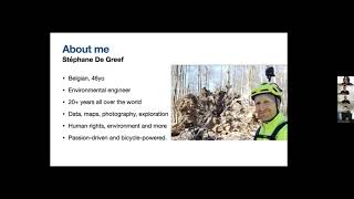
Mapillary Webinar: How to map a city with street-level imagery and learn more about Stéphane De Greef’s journey to capture street-level imagery in every street in Brussels. We hosted Stéphane De Greef, an environmental engineer and open mapping enthusiast, recently completed a project where he mapped all the streets of Brussels, Belgium using only his bicycle, cell phone, and a 360° GoPro camer...

Mapillary & RapiD Training // Open Mapping Hubs + Meta
Переглядів 2,2 тис.2 роки тому
Originally recorded 15 July 2022, online only webinar. This webinar gives a tutorial on: 1) Enriching OpenStreetMap with Mapillary 2) Editing OpenStreetMap with RapiD You can join the RapiD Telegram chat at t.me/mapwithai or via the HOTOSM Slack on the #mapwithai_feedback channel. Get started with Mapillary at: mapillary.com/app Map with RapiD at: mapwith.ai/rapid

How to Use Mapillary Smart Edits in JOSM
Переглядів 4,3 тис.3 роки тому
Mapillary has introduced a new capability in the Mapillary plugin for JOSM, which allows for adding AI-detected map features using an accelerated workflow. Objects that were detected from Mapillary street level imagery can now be added to the map with just a few clicks.

YouthMappers Training Seminar: Introduction to Mapillary + OpenStreetMap
Переглядів 2,5 тис.4 роки тому
Mapillary Solutions Engineer Chris Beddow joins YouthMappers from around the world to review how to best use Mapillary for editing OpenStreetMap. This seminar includes a summary of how to use Pic4Review, the Mapillary verification projects, set up a Mapillary organization, upload images with the Mapillary desktop uploader, and request map feature data in OpenStreetMap iD editor.
![Mapping Against Covid-19 [webinar]](http://i.ytimg.com/vi/lbKfPamNyUs/mqdefault.jpg)
Mapping Against Covid-19 [webinar]
Переглядів 6114 роки тому
The outbreak of Covid-19 has brought much of the world to a standstill. Maps, however, remain crucial. Although many of us have to stay indoors at the moment, improving the map means that we're able to help those at the forefront of the battle against Covid-19. Chris Beddow, a long-time OpenStreetMapper and Solutions Engineer at Mapillary, walks us through how to improve OpenStreetMap with the ...

Mapping Hospitals - Mapillary Tutorials
Переглядів 1,1 тис.4 роки тому
This is a quick video to show you how you can add or correct building polygons. Building outlines will ensure important healthcare facilities are rendered correctly in applications that rely on OpenStreetMap data. Right now we are looking at a MapRoulette task to review and improve hospital polygons throughout the Philippines. MapRoulette is a tool that allows us to focus on specific map attrib...

Mapping Pharmacies & Supermarkets - Mapillary Tutorials
Переглядів 4244 роки тому
Pharmacies and supermarkets are some of the critical amenities that will remain open during this time. Updating the location and opening hours of these amenities is particularly important. Street-level imagery or local knowledge will be needed to confirm these details, as satellite imagery is not sufficient. Focus on an area you’re familiar with or an area with enough street-level imagery to di...

Explaining Mapillary: How it works
Переглядів 20 тис.4 роки тому
From imagery to map data, here's how collaboration means that everyone gets better maps as a result. Read more on mapillary.com.
Multi-Object Tracking and Segmentation from Automatic Annotations
Переглядів 2 тис.4 роки тому
Multi-Object Tracking and Segmentation from Automatic Annotations
An interview with Jessica Bergmann of Humanitarian OpenStreetMap Team
Переглядів 1964 роки тому
Edoardo Neerhut, Mapillary Strategic Partnerships Manager, talks to Jessica Bergmann, HOT Partnerships and Community Programs Associate at HOT Summit 2019 about #map2020
An interview with Adrien Pavie, creator of Pic4Review
Переглядів 1204 роки тому
Mapillary Solutions Engineer Christopher Beddow interviews Adrien Pavie, creator of Pic4Review at State of the Map International 2019
Semantic segmentation point cloud of Elandgracht, Amsterdam
Переглядів 7725 років тому
This is an example of a dense point cloud constructed with the Mapillary technology (Structure from Motion). The City of Amsterdam captured 800,000 panoramic images of the city and brought them to Mapillary as an open data initiative. In just a week's time, the street-level views and the map data derived from the imagery have been made available for anyone to use. Read more: blog.mapillary.com/...
#map2020 - Map Editing Webinar 2
Переглядів 2945 років тому
This is a portion of the webinar covering the Map Editing Webinar for our #map2020 participants. This webinar was recorded with new participants and has some great information. The previous Map Editing Webinar can be found here: ua-cam.com/video/xhoKc2saMgc/v-deo.html The Capture & Upload Webinar can be found here: ua-cam.com/video/NIR2_SR5nLo/v-deo.html The slideshow from the webinar can be fo...
#map2020 - Map Editing Webinar 1
Переглядів 3095 років тому
This is the second of two webinars for our #map2020 participants. The slideshow from the webinar can be found here: docs.google.com/presentation/d/1DdeqZEpGnJWBHn71WnLj_y27Ghzt3rPMHD4GU934sYw/edit?usp=sharing
Mapillary for Organizations: Creating Your Account
Переглядів 9955 років тому
Mapillary for Organizations: Creating Your Account
Mapillary Computer Vision Update: Fall of 2018
Переглядів 3 тис.5 років тому
Mapillary Computer Vision Update: Fall of 2018
Mapillary Semantic Segmentation (video demo 3)
Переглядів 1,2 тис.6 років тому
Mapillary Semantic Segmentation (video demo 3)
Mapillary Semantic Segmentation (video demo 2)
Переглядів 1,1 тис.6 років тому
Mapillary Semantic Segmentation (video demo 2)
Mapillary Semantic Segmentation (video demo 1)
Переглядів 2 тис.6 років тому
Mapillary Semantic Segmentation (video demo 1)
Mapillary - Scalable Image Collection and Map Data Creation
Переглядів 2,6 тис.6 років тому
Mapillary - Scalable Image Collection and Map Data Creation
Adding Building Data in OpenStreetMap
Переглядів 10 тис.7 років тому
Adding Building Data in OpenStreetMap
Can you make any money mapping ?
Hello, I wanted to know if it is possible to use an api to obtain data related to tracking a special object or not?
Can you delete what was uploaded using Mapillary to osm?
I would like to have a 360 camera here in Brasília 😅
If there is ever a camera grant scheme for Australia I would be keen to map bike paths locally.
any plans for making a Unreal Engine Plugin to allow for loading the point cloud into UE? perhaps it could run threw Cesium im not sure but id love to load a dense point cloud from mapillary into UE :)
How will the plugin know the next time you load the imagery that this hydrant from the street-level photos has already been added to the map?
Great!🎉
@Mapillary How can I download the point cloud data, in general, for any city ?
How would I go about applying to work at Mapillary?
Great video, thanks. I missed a big chunk of this by over-concentrating on the ongoing things :)
This is one the few alternatives to Google Street View, that has imagery at the street level
Nice way to edit OpenStreetMap
I hope to see a mapillary plugin one day for the unreal engine, itd slap the mapillary point could into unreal that'd be sick
how to delete account?
I like the concept of Mapillary. But I'm confused as to the business concept. Is this open source? Who owns the data? Why would I dedicate my time and money helping this project? How are they planning to make money? I understand the need to digitize the world, in fact, I see it as critical. But Google is already doing this (and gladly capturing my data streams to do it), where is the advantage of this project?
facebook bought mapillary a while back so i dont know what their business model is now. before, one of the use cases was maybe local councils who might have to manually keep track of road signs, benches, bins etc which could take months/years but with something this you could drive every road in a city in a week and have objects show up on the map any photos taken were owned by whoever took them, last time i checked anyway. i think for most contributors it was that mapillary integrated with openStreetMap so it made it much easier to capture footage and then view that in the openStreetMap editor later on. i dont contribute anymore myself. i was fairly content with mapillary (possibly) making money from the images i captured in return for the openStreetMap integration, but i dont like or trust facebook as a company and i dont think google is much better either. tbh we need more projects like this, and ones that are used for everyone's benefit and not just for some companies or shareholders profit
You can mumble, mumble, mumble and mumble with the Mapillary plugin for JOSM. Sort out the volume level.
For anyone looking to put up stuff like this, if you don't know how to master voiceovers just go to auphonic and let their system automatically set you up.
Turn on subtile
@@dev_mind no. Sort out the volume level. Subtitles should NEVER be necessary for a video like this. If they are then the audio PA system operator screwed up and/or the presenter has incredibly poor microphone technique. Incidentally I am very much qualified to say this as I am an experienced PA operator, albeit an amateur one. I have made mistakes which messed up levels before. I've also had to deal with appalling microphone technique as well. Having such poor sound is also a violation of equalities legislation as it prevents the blind from listening to the presentation. Telling the blind to "use subtitles" is actually illegal in a great many jurisdictions.
Superb!
😲😲 wow
Very useful, a thanks.
Audio level way low (:-(
To understand better turn on subtile
How could I get exact mileage of a location from the Mapillary Imagery?
looking at the video, a lot of what you said you would put in the notes you never published and looking for pick4review.pavie.info doesn't seem to exist. Please can you post the links in the chat
You mistyped the address, it's pic4review.pavie.info/
can you use a dashcam to collect images?
I wish mobile app software engineers made robust apps
i am happy to be your sample!....
Ji
First.
CB radio and cardboard tube for horrible audio? (:-(
Great work!
Do you offer point clouds as product? can theese be seen online prior to order?
Nicely integrates with OpenStreetMap/OSM (:-)
Wondering if Mapillary will get acquired by some tech giant
Seriously hope not!
Too Late. It was bought this Month by Facebook :(
I applied to drive for you guys. How long does it usually take to get a reply?
You click so fast through options, and it seems like you're talking to yourself. I couldn't follow.
impressive.. what tool did you use to visualise the point clouds in that way? open source or proprietary?
2019H3 none cloud points (((
2019H3 none (((
Tip: instead of holding phone in hand or on selfie stick, you can get an inexpensive chest harness with flexible angle adjustments.
Yeah, that what we want!
+1
Can you get paid doing this???
VR DRIFTER yes you can. Checkout Mapillary’s website.
So ~500 person-min. to map the campus - good deal.
0:26 I'd like to know what the bike phone rig components are
User-facing web view (360 camera image most of us won't create) jumps to some proprietary internal app view. Some narration explanation would be helpful.
0:20 interesting that it doesn't identify giant pavement turn restriction markings or zebra crosswalk
No sound. You guys literally have the tools to put out tons of cool videos with cool 3d graphics. Point cloud mapping high tech feature recognition state of the art explanations of what you do and why you matter.
Pointless, gratuitous video. (:-( Blog post has actual info - that should have been demonstrated in video.